Precise field boundaries with remote sensing

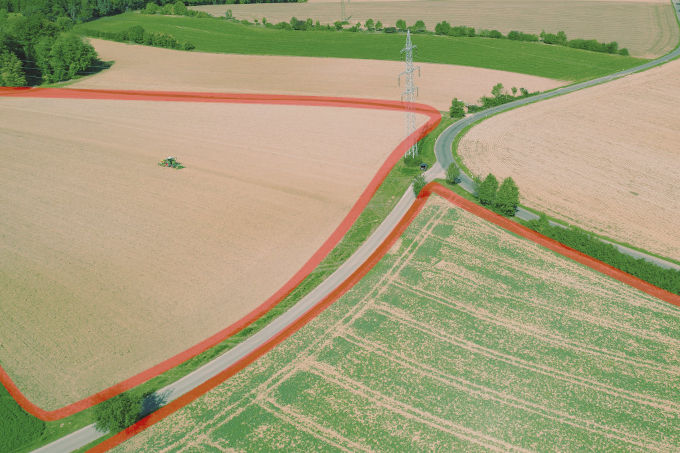
Fields are agriculture's most valuable asset. Our AI models use satellite data to calculate field contours to the nearest metre.

Precise field boundaries as an API service

Our field boundaries are based on Sentinel-2 imagery with a resolution of 10 metres. Our AI model recognises areas with the same vegetation pattern and forms a field from them. The result is high resolution field boundaries with metre accuracy. The field boundaries are available to our customers via our API. All field boundaries within a bounding box or the field boundaries to an exact GPS point can be queried. The geodata is delivered as GeoJson and can be used directly in your system.


Try our demonstrator


Demo regions in different countries are defined in the following demonstrator. Select the region of your choice in the dropdown in the top left corner of the demonstrator. You can move the map with the mouse. The field boundaries are reloaded for the new area. If no field boundaries are visible, they are outside the demo region. You can change the zoom level of the map (using the plus/minus buttons at the bottom right or the mouse wheel). From a certain zoom level, the field boundaries are hidden. Zoom in again to display the field boundaries again. Have fun trying it out.

  • Precision Field boundaries to the metre

    Our many years of experience and our pool of ground-trouth data enable super-resolution refinement of the result contour. This makes it possible for the result to be more accurate than the input data.
  • Simplicity Ready to use REST API

    We use standards to make our products as easy to use as possible. Our API is a state of the art REST interface. You receive an API key and Open API documentation. The results are returned as GeoJson. This makes our service quick and easy to use.
  • Flexibility Field boundaries for your regions

    We calculate field boundaries continuously and regularly for our target regions. The target regions are primarily in Europe and are continuously expanded in line with the rollout of our farm management software. Please enquire whether your regions are already available. We also extend regions and calculation times at the request of our customers.

It's the detail that matters! Technology

By using multiple satellite images, our multi-target AI model is able to compensate for registration errors and calculate the field boundaries with an accuracy of up to one metre in super-resolution. Efficiency is a top priority. The AI model recognises not only the field boundaries but also the crops in a single step.

Innovative and versatile Applications

The areas of application are diverse. The following are examples of different areas of application and economic sectors:

  • Agricultural planning, logistics and documentation
  • Precision farming and vegetation monitoring
  • Environmental monitoring: land use and changes
  • Insurance and disaster management
  • Climate and environmental management
  • Administration and compliance monitoring
  • Transparent and calculable! Pricing

    The price for using the API service is hectare-based and depends on the intensity of use. The higher the annual volume requested, the more favourable the price per unit area. Estimate the annual area volume and obtain a non-binding offer.

    Leverage the potential!

    Are you interested in our API services? Get a trial access now!
    Contact our experts!